Kujawsko-Pomorska Digital Library contains 263 780 digital objects
Object
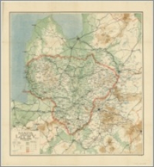
Title: Mapa Litwy : podziałka 1:600 000
Description:
Skala 1:600 000 ; 1 mapa : kolor. ; 85x79 cm, na ark. 97x89 cm, złoż. 25x15 cm. ; Tyt. z mapy ; Rzeźba terenu przedstawiona barwami hipsometrycznymi i punktami wysokościowymi
Contributor:
Wojskowy Instytut Geograficzny.
Publisher:
Place of publication:
Format:
Original identifier:
Language:
Digital object identifier:
Rights:
Domena publiczna (Public domain)
Access Rights:
Resource Identifier:
Digitalisation:
Biblioteka Uniwersytecka w Toruniu
Original in:
Biblioteka Uniwersytecka w Toruniu
Object collections:
Last modified:
Nov 15, 2023
In our library since:
Feb 14, 2017
Number of object content hits:
306
Number of object content views in DjVu format
297
All available object's versions:
https://kpbc.umk.pl./publication/158496
Show description in RDF format:
Show description in OAI-PMH format:
| Edition name | Date |
|---|---|
| Mapa Litwy : podziałka 1:600 000 | Nov 15, 2023 |
Objects Similar
Friederichsen, Richard (1879-1956) Oželis, Karlas Augustas (1857-1951) L. Friederichsen & Co. (Hamburg) C. L. Keller (Berlin)
Charpentier du Moriez, Ferdinand Ludovic Marie Philomene (1847-1923)
Vol'ter, Eduard Aleksandrovič (1856-1941)
Kurnatowski, Oskar
Łukaszkiewicz, Julian Antoni (1857-1937)


