Kujawsko-Pomorska Biblioteka Cyfrowa udostępnia 263 840 obiektów cyfrowych
Obiekt
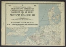
Tytuł: Schematyczna mapa kolei Europy Środkowej ze wskazaniem największych dopuszczalnych nacisków kół na szyny i rozstępów skrajnych osi = Carte schématique de L'Europe Centrale avec iIndication de la charge maximum par roues et de l'écartement maximum des essieux extrêmes
Opis:
1 mapa na 4 ark. : kolor. ; 3 ark. 70x91 cm, 1 ark. 70x100 cm. ; Skala 1:500 000. ; Mapy poboczne: południowa część Włoch, 1:2 000 000, Zagłębie węglowe. ; W prawym górnym rogu tabelka z objaśnieniami. ; Tytuł w języku polskim i francuskim, treść mapy wielojęzyczna.
Współtwórca:
Groszek, Władysław ; Polska. Ministerstwo Komunikacji (1918-1939) ; Zakłady Graficzne im. Komisji Edukacji Narodowej (Bydgoszcz)
Wydawca:
Nakład Ministerstwa Komunikacji ; (druk. Zakłady Graficzne "Bibljoteka Polska")
Miejsce wydania:
Format cyfrowy:
Identyfikator oryginału:
Język:
Prawa:
Domena publiczna (Public domain)
Prawa dostępu:
Identyfikator zasobu:
Digitalizacja:
Wojewódzka i Miejska Biblioteka Publiczna w Bydgoszczy
Lokalizacja oryginału:
Wojewódzka i Miejska Biblioteka Publiczna w Bydgoszczy
Źródło dofinansowania:
Projekt e-Kultura WZP.273.55.2014
Kolekcje, do których przypisany jest obiekt:
- Kujawsko-Pomorska Biblioteka Cyfrowa > Dziedzictwo kulturowe > Mapy
- Kujawsko-Pomorska Biblioteka Cyfrowa > Polecane
- Kujawsko-Pomorska Biblioteka Cyfrowa > Kolekcje uczestników > Wojewódzka i Miejska Biblioteka Publiczna im dr. Witolda Bełzy w Bydgoszczy
Data ostatniej modyfikacji:
15 lis 2023
Data dodania obiektu:
3 lut 2017
Liczba wyświetleń treści obiektu:
94
Liczba wyświetleń treści obiektu w formacie DjVu
95
Wszystkie dostępne wersje tego obiektu:
https://kpbc.umk.pl./publication/175746
Wyświetl opis w formacie RDF:
Wyświetl opis w formacie OAI-PMH:
Obiekty Podobne
Instytut Kartograficzny i Wydawniczy "Glob" J. Chodorowicza
Gotz, Marceli Walkiewicz, Władysław
Osiecki, Józef (1827-1901)
Dane kontaktowe
Odwiedź nas!