Kujawsko-Pomorska Digital Library contains 263 771 digital objects
Object
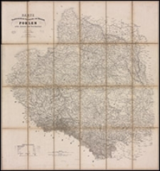
Title: Karte von Oesterreichisch - Preussisch - und Russisch - Pohlen : nebst Kurland und West-Russland
Description:
Skala [około 1:1 400 500] ; 1 mapa : dwukolorowa ; na arkuszu 92x85 cm, złożona w okładce 24x16 cm ; Tytuł z mapy ; Data wydania według Suchmaschine des Österreichischen Bibliothekenverbundes ; Rzeźba terenu przedstawiona cieniowaniem w kolorze sepii ; Mapa pokazuje obszar od Koszalina do Opola i od Velikie Luki (Białoruś) do Kiszyniowa (Mołdawia)
Contributor:
Leykam, Andreas (1752-1826) ; H. Haessel Verlag (Lipsk)
Publisher:
Place of publication:
Format:
Original identifier:
Language:
Relation:
Digital object identifier:
Rights:
Domena publiczna (Public domain)
Access Rights:
Resource Identifier:
Digitalisation:
Biblioteka Uniwersytecka w Toruniu
Original in:
Biblioteka Uniwersytecka w Toruniu
Sponsor:
Program Operacyjny Polska Cyfrowa POPC.02.03.01-00-0039/18
Object collections:
Last modified:
Nov 15, 2023
In our library since:
Sep 30, 2020
Number of object content hits:
67
Number of object content views in Galeria format
83
All available object's versions:
https://kpbc.umk.pl./publication/211918
Show description in RDF format:
Show description in OAI-PMH format:
| Edition name | Date |
|---|---|
| Karte von Oesterreichisch - Preussisch - und Russisch - Pohlen | Nov 15, 2023 |
Objects Similar
Gräf, Carl (1822-ca 1897) Müller, A. Geographisches Institut (Weimar)
Weiland, Karl Ferdinand (1782-1847) Geographisches Institut (Weimar)
Engelhardt, Friedrich Bernhard (1768-1854) Maré, Carl (fl. 1804-1845) Simon Schropp und Comp. (Berlin)
Güssefeld, Franz Ludwig (1744-1808) Homannsche Erben Rausch, Johann Lorenz Jacob
Engelhardt, Friedrich Bernhard (1768-1854) Brose, Heinrich Simon Schropp und Comp. (Berlin)


